We are back from our incredible adventure: crossing the intense island of Réunion on foot. After 11 days on the GR R2, the iconic trek that links the south and the north of the island, our heads and legs are still full of memories. And what a journey! Crossing Réunion on foot means walking through landscapes as varied as they are spectacular, from wet forests to rugged ridges and remote cirques. For us, it was Reunion Island hiking at its most complete.
In this article, I share everything we wish we had known before leaving. You will find practical tips and highlights. But also the surprises and challenges we met on this demanding trail of 160 kilometres and more than 10,000 metres of climbing. Get ready to discover Réunion in a different way, far from the beaten track, at the pace of a walk that reveals the raw beauty of the island.
So, do you want to take on the GR R2 and live this intense crossing of Réunion yourself? Follow us on this journey into the heart of the island. And find out how this 10-day trek left a mark on us far beyond what we imagined.
Sommaire
Reunion Island hiking: the GR R2 at a glance
For Reunion Island hiking, the GR R2 crosses the island from south to north over about 160 km, with more than 10,000 m of total climbing. People usually walk it in 10 to 14 days. We did it in 11 days, from Basse Vallée to Saint-Denis, in October. The highlights are the Piton de la Fournaise, the Plaine des Sables, the Piton des Neiges (3,071 m) and the Cirque de Mafate. We slept in gîtes and huts, for about €50 to €66 per person with dinner and breakfast, and we booked ahead.
What is the GR R2?
The GR R2 is much more than a simple hiking trail. It is a real immersion in the essence of Réunion. The trek crosses the island from south to north (and that is the direction we took), and it covers about 160 kilometres. It takes you through landscapes as varied as they are stunning. You go from the arid, moon-like slopes of the Piton de la Fournaise to lush tropical forests. And through the iconic cirques of Mafate and Cilaos. The GR R2 shows you Réunion in all its splendour and harshness.
A condensed version of the island
Unlike the GR R1, which stays around the legendary Piton des Neiges, the GR R2 is a condensed version of the island. You discover its contrasts, its microclimates and its steep reliefs. It is a dream route for hiking fans looking for a challenge. The route can look intimidating with its 10,000 metres of total climbing. But that is exactly what makes it one of the most legendary treks of the Indian Ocean. It is a demanding route, often done in 10 to 14 days. And we chose to take it on in 11 days to make the experience even more intense.
By starting in the south, we knew the first days would plunge us straight into the atmosphere of the Piton de la Fournaise, one of the most active volcanoes in the world. From the very beginning, the effort is rewarded with spectacular panoramas. This variety of landscapes, this sense of adventure and of pushing your limits, makes the GR R2 a trek apart. Each stage reveals a new side of the island.
Anyone setting out should know that this trek is a physical commitment, and a mental one too. You have to be ready to face everything: dizzying ridges, steep descents, nights in damp huts and chilly mornings. For us, the challenge was worth every drop of sweat, every incredible view and every meeting on the trails.
Why choose the GR R2 for Reunion Island hiking?
Reunion Island hiking on the GR R2 is much more than a simple hike. It is the promise of a real journey, a full crossing of Réunion that lets you live the island from the inside, far from the beaten track. We knew it would be intense before leaving. But it was hard to imagine how much each stage would shake us up and amaze us.
Landscapes with nothing in common
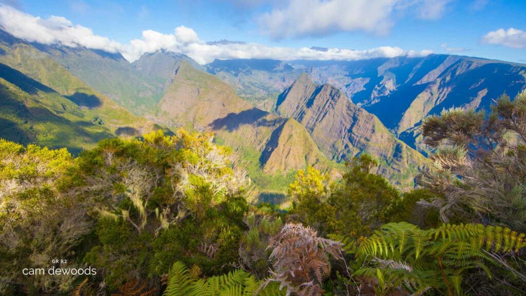
The “intense island” lives up to its nickname: every day showed us a completely different setting. We start on the arid, almost lunar slopes of the Piton de la Fournaise. A few days later, we are deep in tropical forest, surrounded by giant ferns and wild orchids. Then we climb onto the ridges of the cirques, with stunning views of isolated villages like Marla or Cilaos. This trek is a summary of all the diversity of Réunion, in large format.
A physical and mental challenge, but so rewarding
Let’s not pretend: the GR R2 is gruelling. With endless climbs, steep descents and days of walking one after another, tiredness sets in fast. But that is also what makes the experience memorable. Every day, you push your limits a little further. And at every stage you feel a little prouder of what you have just done. When you reach the summit of the Piton des Neiges at dawn, with a clear view over the whole island, you forget the pain and the fatigue at once. It is worth every effort, every blister.
The experience of Mafate’s remote villages
If you really want to discover the authentic Réunion, the one hiding behind the beaches and the tourist sites, the GR R2 is the way to go. Crossing the Cirque de Mafate means entering a world apart. There is no road here, only trails. You meet villagers who get around on foot, children playing outdoors and improvised grocery shops. In Marla or La Nouvelle, it feels like stepping back in time. This is where you really understand the cultural richness and diversity of the island.
A time to disconnect and reconnect
Réunion is a total change of scenery, but also a return to basics. On the GR R2, you are far from the noise, from social media, from daily life. You find yourself face to face with yourself, living at the rhythm of the sun, the mountains and nature. It is a real breath of fresh air, a way to disconnect from everything and focus on the essentials. And honestly, it does you good.
The GR R2 in 10 days: our itinerary
We chose to start our adventure in the Basse Vallée area, in the south of the island, and to work our way up to Saint-Denis in the north. Here is an overview of our route, without going into too much detail (we will tell you everything when we are back!):
Stage 1: Basse Vallée, the start of the GR R2
As soon as we left the airport, we headed to the south of the island: Basse Vallée. We only needed to take 2 buses, and the adventure began. By the way, there is a very nice little bakery (and the sweet potato cakes there are delicious) right next to the starting point.
From the start, we climb gradually into a very dense forest. And the path sinks into lush vegetation, typical of Réunion. Vanilla plantations keep us company. The climb is continuous, but these first kilometres, lulled by birdsong and the intense green of the plants, pass quickly.
The best-known gîte is the Gîte de Basse Vallée. But given the reviews we had read, we preferred to book another gîte, a little off the GR R2 route. A short detour of 45 minutes took us to the Gîte Théophane et Yoleine, our first stop. A pleasant surprise: the place is welcoming, the food is delicious, and the view over the ocean is simply magical. It was a perfect warm-up to start the trek with a smile.
✨ Highlight: The vanilla plantations, the view of the sea
🥾 Distance/Elevation: 6 km / +440 m
🛏️ Accommodation: Gîte Théophane et Yolaine, very nice, clean and comfortable, about €60 per person with dinner and breakfast.
Stage 2: Basse Vallée to the Refuge du Volcan
At dawn, we leave the Gîte Théophane et Yoleine to start this second stage with a steep climb that wakes us up quickly. The first kilometres go through tropical jungle, where the vegetation is dense and lush, like the day before. We climb for nearly 8 km, about 1,500 m of positive elevation on this first section. And each step brings us closer to the desert plateau typical of the volcano.
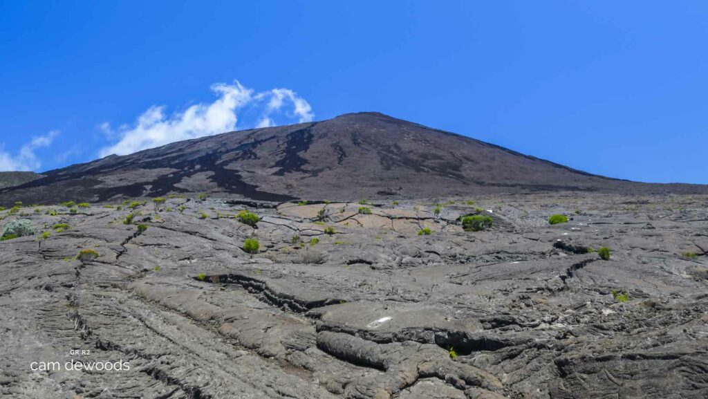
The transition is striking: after the forest, we find ourselves on arid, almost lunar ground, and the air becomes drier. This is where the Piton de la Fournaise reveals itself, imposing and fascinating, surrounded by the crest that we follow all along the trail. The view is clear, and you feel the full power of this volcanic land.
After about 6 hours of walking, we reach the first car park, an important landmark before leaving the GR R2 and heading to our accommodation. A final straight leads to the Gîte du Volcan and, after such a demanding day, asks for one last effort.
At the hut, the welcome is correct, even if the atmosphere is a little impersonal. The buffet is quite good, and the dormitories, although old, are clean, with sheets provided. The toilets and showers are passable, but enough after such a long stage.
✨ Highlight: The spectacular view of the Piton de la Fournaise.
🥾 Distance/Elevation: 20 km / +1,935 m / -200 m
🔴 Difficulty: A gruelling day with 2,000 m of positive elevation.
🛏️ Accommodation: Gîte du Volcan, industrial but practical, about €66 per person with dinner, breakfast and the next day’s packed lunch.
Stage 3: Gîte du Volcan to Bourg Murat
After a so-so night for me at the Gîte du Volcan, we take back the path we left the day before. On this GR R2 crossing, we do not climb the Piton de la Fournaise. And we will come back here in a few days to discover a bit more of the volcano. Back on the trail, we head across the Plaine des Sables, which offers a lunar show with its mineral expanses and contrasting colours.
As we climb towards the Sainte-Thérèse oratory, the landscape becomes more rugged and reveals beautiful views of the Piton de la Fournaise and its surroundings. We then keep going along several ridges and trails lined with volcanic vegetation. We cross areas where the slopes drop towards the Plaine des Sables. And where panoramic views of the cirques appear from time to time.
The path continues to the fork towards the volcano forest trail. And we pass iconic places such as the Nez de Bœuf (at about 2,000 m), where you can stop to enjoy the sweeping view of the east coast of the island. The stage ends with a gradual descent to Bourg Murat, where our hotel, Les Écrins, is waiting for a well-earned evening of rest after this demanding day.
✨ Highlights: Crossing the Plaine des Sables, a lunar landscape, a great view from the Sainte-Thérèse oratory, a lookout over the cirque de Cilaos, passing the Nez de Bœuf with a panorama of the east coast
🥾 Distance: 20.39 km / +377 m / -1,070 m
🛏️ Accommodation: Hôtel Les Écrins, very nice and comfortable
Stage 4: Bourg Murat to the Refuge du Piton des Neiges
The stage starts gently from Bourg Murat, with the first 5 kilometres on a flat road, a good way to warm up before the long climb. Little by little, the start of the ascent appears and the difficulty rises gradually. The real climb begins, leading to the Mare à Boue, where the landscape changes and opens up to wider views of the surrounding mountains.
The climb continues steadily.
And every step gets more intense as we approach the Gîte Caverne Dufour (or Piton des Neiges hut). The particular thing about this day is that we did it at the same time as the runners of the Diagonale des Fous. This added a special energy to the route and let us cheer them on all the way, although the weather was difficult and the sky often covered.
A night at the Piton des Neiges hut
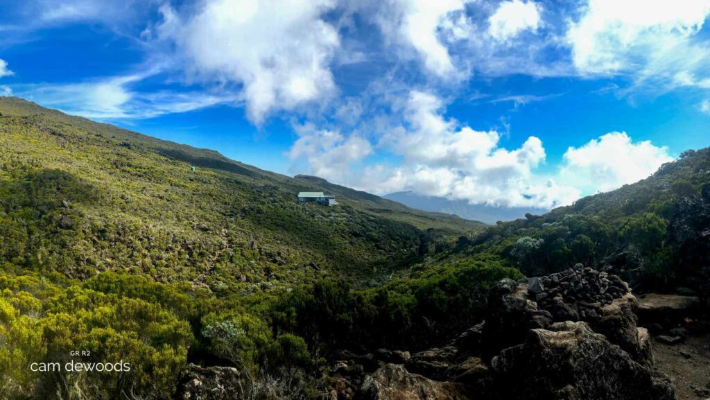
The Piton des Neiges hut, although rustic and with limited drinking water, remains an essential stop for hikers. The dormitories are spread over three levels and hold up to 15 people each. They are quite basic, and it is better not to sniff too closely at the sweet smell escaping from the blankets. Fortunately, toilets and a thin trickle of water were available that evening (apparently this is not always the case, see the Google reviews).
One of the strong points of the hut is that you can leave your bag the next morning and set off light for the Piton des Neiges climb at sunrise, a magical moment that everyone wants to live.
✨ Highlights: A steady climb to the Mare à Boue with views of the summits, the legendary starting point for the Piton des Neiges climb
🥾 Distance and elevation: 19.17 km / +1,177 m / -320 m
🛏️ Accommodation: Refuge du Piton des Neiges, authentic atmosphere, booking advised, about €52 per person with dinner and breakfast. Bring your own water, or buy some on site.
Stage 5: Piton des Neiges to Cilaos
This stage was one of the most awaited moments of our adventure. The climb of the Piton des Neiges, the highest point of the island at 3,071 m, is a challenge we took on with excitement and apprehension. Leaving before dawn, in complete darkness, makes the experience unforgettable: every step is guided by the glow of head torches and the hope of seeing the sky light up.
We left around 3 am, when most dormitories wake up and everyone sets off with more or less energy to conquer the 600 m of climbing ahead. After almost 2 hours of steady climbing, the show lives up to our expectations: the sunrise over the ocean and the surrounding cirques is simply stunning. We stand speechless in front of this sea of clouds tinted with pink and gold.
We then go back to the hut (where we all left our bags) for breakfast. It is 8 am, and yet the day already feels well under way for us. Fortunately, this is a “short stage” that will take us to Cilaos.
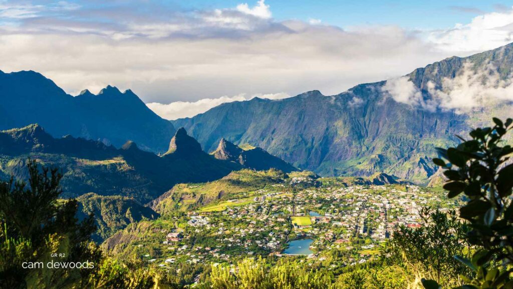
The descent, although beautiful, is long and technical. My legs are really tired, and I cannot help thinking of the Diag runners, who must have done this the day before after the climb to the hut. It drops steeply, with impressive views of the cirque de Cilaos, which gradually unfolds, and of the Piton des Neiges.
✨ Highlight: The magical sunrise at the top of the Piton des Neiges, the legendary Bloc descent to Cilaos
🥾 Distance/Elevation: 15 km / +789 m / -2,000 m (including about 6 km and 600 m up and down for the Piton climb).
🛏️ Accommodation: Various places to stay in Cilaos, with options for every budget.
Stage 6: Cilaos to Marla
We were looking forward to this stage: entering the Cirque de Mafate! From the start in Cilaos, the view of the Col du Taïbit gives us a taste of the adventure ahead. The descent to the Bras Rouge waterfall is pleasant.
The climb to the Col du Taïbit is gradual, sometimes a little long, but the panorama is really incredible. We pass the Trois Salazes herbal tea house, a lovely little spot where you can stop for a local tea.
Reaching the top of the Col du Taïbit marks a real turning point and the entrance to Mafate.
We go down to Marla, a village that feels completely out of time. It is small, quiet and full of gîtes that welcome passing hikers. We found shelter at the Gîte de Marla run by Yolande Hoareau, who welcomed us with a smile. The gîte is very pleasant, with small human-sized bungalow rooms. It is quite cosy, with a hot shower and clean toilets. And a special mention goes to the grocery shop and the bakery nearby, perfect for stocking up for what comes next.
✨ Highlight: The long-awaited entry into the Cirque de Mafate, the views over Cilaos and reaching the top of the Col du Taïbit.
🥾 Distance/Elevation: 13.49 km / +1,328 m / -800 m
🛏️ Accommodation: Gîte de Marla, simple and warm, run by Yolande Hoareau, about €55 per person with dinner and breakfast.
Stage 7: Marla to Roche Plate
We leave Marla, this peaceful village tucked in the heart of Mafate, with a touch of nostalgia. Marla feels out of time, surrounded by the raw nature of Réunion and very quiet (despite a few helicopters passing). Then we head for La Nouvelle, crossing varied terrain and changing vegetation. When we arrive in La Nouvelle, we are struck by the more “touristy” atmosphere of the village, with its small refreshment stands and rest stops for hikers, a contrast with the calm of Marla.
We then start the descent to the Rivière des Galets, a technical and quite steep section that tests our legs and ends with many river crossings that add a good dose of adventure.
After the river, we tackle the climb to Roche Plate.
It is short but intense, and I must admit it finished me off! On arrival, the îlet of Roche Plate has a completely different feel from the previous ones, on the mountainside with houses on stilts. The panorama is spectacular again, with a 360-degree view of Mafate and in particular the well-known Maïdo.
For the night, we drop our bags at the Gîte Chez Merlin. The welcome is quite basic and the food is not really up to scratch, but the facilities are functional.
✨ Highlight: Discovering La Nouvelle, crossing the Rivière des Galets
🥾 Distance/Elevation: About 13 km / +700 m / -1,200 m
🛏️ Accommodation: Gîte Chez Merlin, simple welcome, very average food, decent toilets and showers, about €55 per person with dinner and breakfast.
Stage 8: Roche Plate to Îlet à Bourse
Leaving Roche Plate, the trail climbs to the Brèche, with an impressive panorama of the cirques. This section is one of the highlights of the day, where you can really appreciate the wild grandeur of Mafate. After the Brèche, a long descent begins, passing through several picturesque îlets before reaching the îlet des Orangers.
The descent continues once more to the Rivière des Galets.
It is always a very pleasant stop to cool off, ideal to regain strength and prepare for the climb that follows.
After the river, the trail rises gradually towards Grand Place, again with demanding climbing, especially with the weight of the bag. We finally arrive at Îlet à Bourse, a hamlet tucked into the mountain.
✨ Highlight: The spectacular passage through the Brèche and the refreshing crossing of the Rivière des Galets.
🥾 Distance/Elevation: 16.07 km / +1,161 m / -758 m
🛏️ Accommodation: Gîte de l’Îlet à Bourse, about €50 per person with dinner and breakfast.
Stage 9: Îlet à Bourse to Dos d’Âne
Leaving Îlet à Bourse, we start a gentle but long descent towards the village of Aurère. It is another lovely little haven in Mafate, where time seems to have stopped. The village is known for its panoramic views and is very popular, as it is one of the first you can reach when you enter Mafate from this side. But what many people do not know is that it has a great local bakery, a gourmet break not to be missed!
Leaving Mafate
After enjoying this moment, the descent (endless from my point of view) continues to the river, which we cross several times. We leave Mafate this way and find civilisation again for a few metres (there are really a lot of people). It is a striking passage, where the feeling of leaving this isolated world is strong. On this section, the trail gets busier, with families and hikers out for the day, picnic stops. And quite a few 4x4s dropping groups as close as possible to the entrance of the cirque.
The last climb to Dos d’Âne
But for us, the adventure goes on with the climb to Dos d’Âne. This steep trail, a little more rugged and less maintained in places, gives one last intense climb. It is less busy than the trails in the heart of Mafate. And it brings back a feeling of mountain solitude, with grand landscapes in the background, in particular the superb line of the Orangers canal path. The ascent is hard, but arriving at Dos d’Âne, with an open view of the ocean, is simply extraordinary!
This final stage takes us out of the cocoon of Mafate and gradually brings us back to civilisation. It is marked by a touch of melancholy at leaving the calm of Mafate behind. But also by the pride of having crossed this remarkable cirque.
✨ Highlight: Crossing Aurère, the impressive exit from Mafate, the view from Dos d’Âne.
🥾 Distance/Elevation: 18.92 km / +1,216 m
🛏️ Accommodation: Gîte at Dos d’Âne, with a small grocery shop in the village to top up supplies.
Stage 10: Dos d’Âne to Plaine des Chicots
We start with a climb on tarmac from Dos d’Âne to join one of the most popular hikes on the island: the trail to Roche Verre Bouteille and Cap Noir. This viewpoint is very popular, and for good reason: it offers a striking panorama of the Cirque de Mafate, a reminder of the grandeur and isolation of this region.
After the viewpoints, we commit to a steady climb towards Roche Écrite: the trail becomes more immersive and leads us into dense, damp vegetation. The climb is fairly sustained, and the further we go, the wilder the path becomes and the fewer people we meet. This part of the route is marked by a growing dampness, creating an almost mystical atmosphere as we approach the hut.
Located in the heart of the forest, the Plaine des Chicots hut offers basic comfort. But its isolated location and friendly mood more than make up for it. The damp is everywhere, and the facilities are basic. But the meal is pleasant and comforting after this long day of walking. It is a perfect place to rest and enjoy the hiking experience in the middle of untouched nature.
✨ Highlight: Spectacular view of the Cirque de Mafate from Roche Verre Bouteille and Cap Noir.
🥾 Distance/Elevation: 11.50 km / +1,144 m 🛏️ Accommodation: Refuge de la Plaine des Chicots, basic but friendly. And the ambient damp adds a special atmosphere to this forest gîte
Day 11: Roche Écrite to Saint-Denis
Our last day of trekking starts with an attempt to watch the sunrise from the Roche Écrite. Unfortunately, the weather was not on our side, and the clouds decided to deprive us of the show. This (very) early wake-up got us back to the gîte empty-handed and completely soaked. And the gîte itself was very damp too!
Back at the gîte for a well-earned breakfast, before starting our long descent to Saint-Denis. The path winds between cryptomeria trees and ferns, with views of the highlands stretching to the coast. After several hours of descent, we reach the car park, the starting point for those climbing to the Roche Écrite. For us, it is the end of a great adventure.
We keep going down towards Saint-Denis, feeling the return to civilisation little by little. Tiredness starts to show after all these days of trekking. But the excitement of having completed this island crossing gives us one last push.
After 11 days of effort, stunning landscapes and meetings, we finally reach the end. This GR R2, with its challenges and its moments of grace, will stay in our memories.
Essential preparation before you go
As with any long hike, it is important to prepare well before setting off to cross Réunion on foot. It was essential to book the gîte accommodation in advance, especially for nights in popular places like the Refuge du Piton des Neiges. We chose this option to lighten our backpacks and enjoy the landscapes fully, without having to pitch our own tent every evening.
Reunion Island hiking in October on the GR R2
We chose to leave in October for our trek on the GR R2, because it is an ideal time to hike in Réunion and avoids the strong heat. It is also one of the busier periods, which we felt in the price of the plane ticket (ouch, that hurt) and in booking the accommodation. We also had to think about shifting our nights a little, because the most popular huts were sometimes already full. By setting off as soon as we arrived on Réunion soil, we knew we would probably end up on the Diagonale des Fous at some point. But in the end we should manage fine!
The Diagonale des Fous and the GR R2
The GR R2 shares a large part of its route with the iconic Diagonale des Fous, an ultra-trail race that attracts hundreds of runners every year. Our route coincides with the date of this event. And we are likely to meet the end of the pack, especially on Friday. It will be a special moment to meet these warriors of the trails, who complete their crossing in just a few days while we take the time to enjoy every stage.
My latest multi-day hikes: the Jordan Trail and the Via Podiensis.
GR R2 stages in short
Day 1 is short: 6 km and +440 m from Basse Vallée to the Gîte Théophane et Yoleine. Day 2 climbs to the volcano, with 20 km and +1,935 m to the Gîte du Volcan. On day 3, you cross the Plaine des Sables to Bourg Murat (20.39 km, +377 m). Day 4 goes up to the Piton des Neiges hut (19.17 km, +1,177 m). Day 5 starts with the summit at sunrise and ends in Cilaos (15 km, +789 m, -2,000 m).
On day 6, you enter Mafate and sleep in Marla (13.49 km, +1,328 m). Day 7 leads to Roche Plate (about 13 km, +700 m). Day 8 reaches Îlet à Bourse (16.07 km, +1,161 m). On day 9, you leave Mafate for Dos d’Âne (18.92 km, +1,216 m). Day 10 ends at the Plaine des Chicots hut (11.50 km, +1,144 m). Day 11 is the long descent to Saint-Denis.
Reunion Island hiking FAQ: the GR R2 trek
How long does the GR R2 take?
The route is often done in 10 to 14 days. We took 11 days, and we kept some stages short, like the first one and the day of the Piton des Neiges sunrise.
How hard is the GR R2?
It is demanding, both physically and mentally. The trek covers about 160 km with more than 10,000 m of total climbing. Expect endless climbs, steep descents, damp huts and chilly mornings. The effort is rewarded by the views and the encounters on the trail.
Do you need to book accommodation in advance?
Yes. We booked all our gîtes and huts before leaving, especially for popular places like the Refuge du Piton des Neiges. In October, some of the most popular huts were sometimes already full, so we had to shift a few nights.
When is the best time for Reunion Island hiking?
We chose October, an ideal time to hike in Réunion that avoids the strong heat. It is also a busy period, so flights and accommodation cost more and book up fast. Our dates overlapped with the Diagonale des Fous ultra-trail.
Is there drinking water on the route?
Water can be limited. At the Piton des Neiges hut, drinking water is limited, so bring your own or buy some on site. In Mafate, the îlets have small grocery shops and bakeries, which helps you top up supplies.
How much does the GR R2 cost?
We paid about €50 to €66 per person per night in gîtes and huts, with dinner and breakfast. The Gîte du Volcan price also included a packed lunch for the next day. Flights were expensive in October. In Cilaos, you can find places to stay for every budget.