Mont Veyrier is the local mountain for most people who live in Annecy. Trail runners train their legs here, casual walkers bring visiting friends for a Sunday outing, and just about everyone makes an annual pilgrimage to watch the sunset. It’s both a local ritual and a tourist favourite, which means you’re rarely alone on the trail, but it’s also the kind of hike that earns its popularity.
It’s the hike I recommend to every friend discovering Annecy for the first time. Simple but not easy, beautiful, and offering one of the best views over Lake Annecy without requiring a full mountain expedition. The logistics help explain why: you can walk to the trailhead from the town centre in about 20 minutes, or cycle there in a few. No long drive, no complex planning. I do this one regularly with Rhéa, water bottle in the bag, dog on the lead, and that’s enough to be in the mountains.
In this guide, I’ll cover everything you need to know about hiking mont veyrier annecy: the different routes, how to choose between them, practical details, and what to expect at each stage. I’ve walked every path on this mountain: from Petit Port, from the Pré Vernet, from Veyrier-du-Lac, and along the ridge to Mont Baron and the Col des Contrebandiers.
Mont Veyrier Annecy: an iconic summit above the lake
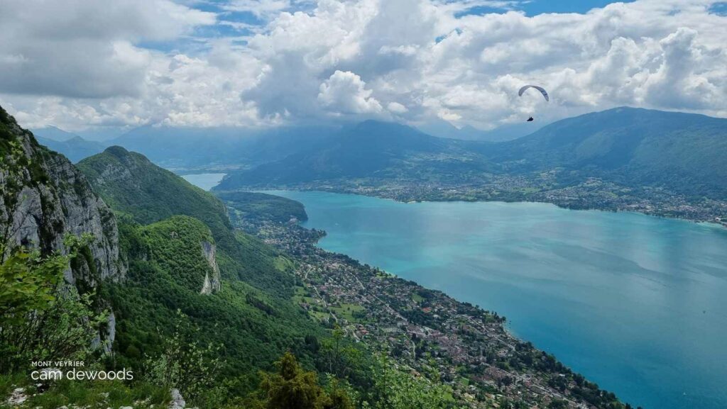
If you’ve spent any time in Annecy, you’ve already seen Mont Veyrier. It’s the mountain directly above the lake, on your left as you walk along the Pâquier park or near the Imperial hotel, directly facing the Semnoz on the other side. The long pale limestone ridge, rising to 1,291 metres, is impossible to miss from the lakeside or the old town.
From below it looks imposing, but once you’re on it the terrain is much more accessible than it appears. What I love about arriving at the summit is the feeling of being between two worlds: the lake spreads out below in every shade of blue, while the Aravis range, the Parmelan massif, La Tournette, and the Semnoz fill the view behind you. On a clear day, you can see Mont Blanc from Mont Baron, the summit just beyond Mont Veyrier on the same ridge.
The mountain has a bit of history too. Mont Veyrier was once served by a cable car, built in 1934, and you can still see the remnants of the infrastructure near the summit. The old cable car station in Veyrier-du-Lac village is now home to the Cinémathèque des Pays de Savoie (the Savoie film archive). It’s one of those details that adds texture to what would otherwise be just a very good view.
Which route to choose for hiking mont veyrier annecy?
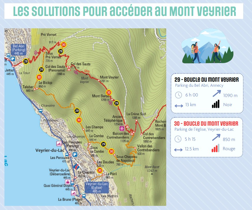
The main advantage of Mont Veyrier is that it offers several routes genuinely suited to different levels. If you’re a beginner or want a relaxed outing with good views and minimal effort, the route from the Col des Contrebandiers or the Pré Vernet car park (when open: see the note below) gives you the summit without a long climb. If you want something a bit more demanding but still very accessible, the Petit Port approach delivers proper elevation and a satisfying full day out.
None of the routes involve technical terrain: no scrambling, no exposed sections that require hands. That said, the mountain does have a bit of bite to it, particularly on the steeper pitches, and it has tested the legs of more than a few people who underestimated it. Worth wearing proper footwear and not expecting a stroll.
I’ll go through the main routes in detail below so you can choose based on where you’re staying, what you’re after, and how much time you have.
The best hiking routes on Mont Veyrier
Loop from Petit Port via Mont Baron: 11 km, +900 m, 3 to 5 hours
Starting from Petit Port is the most practical option if you’re based in Annecy centre or Annecy-le-Vieux. You leave the bike or car along the avenue de Chavoire, walk past the bakery, tighten your laces, and you’re on the trail within minutes. The start is fairly direct: a series of switchbacks climbing straight through beech forest, the path wide and well-marked, impossible to get lost on.
The lake gradually drops away as you climb. The first significant stop is the Pré Vernet, a good place for a water break before continuing towards the Col des Sauts. The gradient eases slightly as you move through the forest, with occasional views across to the Semnoz. When you emerge from the trees, everything changes: pale limestone cliffs, a narrower path, and an extraordinary panorama over Lake Annecy.
The Col des Sauts is one of the finest viewpoints on this route. If your legs are done, it’s a perfectly respectable place to turn back. If you have more in you, continue to the summit of Mont Veyrier, another quarter of an hour from the col, though the actual summit area is fairly unremarkable. The reward comes on the ridge: the traverse to Mont Baron is demanding but spectacular, with views across the lake uninterrupted the whole way. The metal viewing platform at Mont Baron is the photo stop of the route, looking straight down over Annecy with the Bauges and La Tournette framing the horizon.
For the descent, the route continues to the Col des Contrebandiers: steep for about 200 metres, then broadening onto a forest track. From there you have two options: drop down to Veyrier-du-Lac village and return to the start along the lake shore (free beach, swimming possible in summer), or retrace the ridge if you prefer to stay in the forest. Either way, the return is easier than the ascent, and the full loop, with a relaxed pace and time for a picnic at the top, fits comfortably into a half day.
This is the route I’d choose for a first visit: it covers the full character of the mountain from lake-level to ridge, rewards the effort with continuous views, and ends in a village with a beach if you want to make a day of it.
At a glance: 11 km total, +900 m elevation, 3 to 5 hours depending on options. Start: avenue de Chavoire, Petit Port (limited parking, arrive early). Trail markings: yellow then red-white GR, very clear. No water on the route: bring at least 1.5 litres. Key points: Mont Baron viewpoint, Baron-Veyrier ridge, Col des Contrebandiers. Note: steep and slippery sections after rain; busy at weekends. Bonus: return via Veyrier-du-Lac for a swim at the end.
My tips for the Petit Port route
Parking at Petit Port is tight in summer and on sunny weekends. My advice: arrive before 8am, or come in the late afternoon for the sunset. Outside the main season it’s much more straightforward.
The best seasons for this hike are spring and autumn. The temperatures are comfortable, the light is beautiful, and the crowds are thinner. Summer is possible, so start before 8am to avoid the heat and the busiest hours. Winter can be excellent on a clear day, the distant peaks in snow are something else, but check conditions beforehand: some sections can be icy after a cold snap, particularly on north-facing slopes and in shaded gullies. Worth having microspikes in the car from November onwards.
Route from Pré Vernet: 5 to 7.5 km, +350 m, 2h30 to 3 hours (currently closed)
Important note: this route is currently closed. The Pré Vernet car park and the Col des Contrebandiers car park have been subject to access restrictions as part of the Mont Veyrier Management Plan 2024-2029, managed jointly by the City of Annecy, the Grand Annecy authority, the Haute-Savoie Departmental Council, and the commune of Veyrier-du-Lac. The measures aim to protect biodiversity, reduce fire risk, and manage the growing visitor numbers. Check the official Annecy website for the latest situation before planning your visit.
When this access is open, the Pré Vernet route is the most direct way to the summit. You drive up from Annecy-le-Vieux, park at the small col car park at around 820 metres altitude, and you’re already in the forest: no lake-level approach, no long warm-up. For anyone who wants the summit views without the full climb from below, it’s the obvious choice.
The trail begins gently through beech trees on a broad track, then narrows onto a yellow-marked path. The gradient increases steadily to the Col des Sauts at 950 metres, the first open viewpoint, with the lake and the Semnoz visible. This is a reasonable turn-back point for anyone who needs it.
From the col, the path heads north along the ridge. The ground becomes slightly more rocky but stays non-technical: nothing that requires hands, no cables, just a sometimes-steep path with the drop at a comfortable distance. Ten minutes brings you to the summit of Mont Veyrier, and from there the continuation to Mont Baron is straightforward: the metal viewing platform at the top gives an unobstructed view over Annecy, the Bauges to the left, the Aravis behind. On a clear day, Mont Blanc is visible in the background.
Return options from here: same path back (fastest and clearest), or loop via the Col des Contrebandiers and the forest track back to the car park (adds about 15 minutes). Dogs are welcome on this route: no difficult stiles or technical sections, but keep them on a lead near the cliff edges.
At a glance: 5 to 7.5 km return, +350 m, 2h30 to 3 hours with stops. Start: Col du Pré Vernet car park (820 m), currently closed. Trail markings: yellow then red-white GR. No water: bring at least 1 litre, more in summer. Key points: Col des Sauts, Mont Baron viewpoint, Baron-Veyrier ridge. Note: roots and slippery sections after rain; car park fills quickly at weekends (arrive before 9am when open). Dogs allowed; lead required near cliff sections.
Getting to mont veyrier annecy from the town centre
One of the things that makes Mont Veyrier genuinely unusual is how accessible it is without a car. From the centre of Annecy, the Petit Port trailhead is about a 20-minute walk or a few minutes by bike via the lake path. This matters: for most hikes in the Annecy area you need a vehicle, or at least a bus that runs infrequently. Mont Veyrier is different.
By car, the Petit Port starting point is on the avenue de Chavoire (D909), just past the Hôtel Impérial heading south out of Annecy. Parking is free but limited: on summer weekends it fills by 8am. The Pré Vernet approach (when open) is accessed via Annecy-le-Vieux, taking the route du Pré Vernet uphill from the village.
For visitors coming from the UK, Annecy is straightforward to reach: Geneva airport is the closest, around 45 minutes by car or 30-35 minutes by TGV train, with Annecy well-served by direct trains from Geneva station. Easyjet, British Airways and several other carriers fly into Geneva from multiple UK airports. Lyon airport is an alternative at around 1h15 by car. Once in Annecy, the town is compact and walkable, and Mont Veyrier is genuinely reachable on foot from most central accommodation.
Respecting the mountain and the management plan
Mont Veyrier is a natural space that has been under increasing pressure from visitor numbers in recent years. The closure of the Pré Vernet car park is part of a broader management plan put in place by local authorities specifically to address this. It’s worth understanding why these measures exist, because they affect how you plan your visit.
The key rules for all routes:
- Stay on marked trails. Cutting across slopes or leaving the path damages vegetation and soil, particularly on the steeper sections.
- No fires or barbecues anywhere on the mountain or in the forest approaches.
- Take all rubbish with you. There are no bins on the trail. This includes fruit peel and food packaging.
- Keep dogs on a lead, particularly near the cliff edges and in the forest sections where wildlife is present.
- Respect parking rules: do not park on the roadside when car parks are closed or full. The emergency access restrictions cited by local authorities are real, not arbitrary.
- If you’re visiting in summer, consider arriving early or choosing a weekday: a less crowded trail is better for everyone, including the mountain.
The Mont Veyrier Management Plan runs until 2029. Changes to access rules are possible during that period, so check current conditions on the Ville d’Annecy website before your visit, particularly for the Pré Vernet and Contrebandiers approaches.
What to combine with the hike
Mont Veyrier works well as part of a longer day in the Annecy area. A few combinations worth considering:
The beach at Veyrier-du-Lac, just below the Col des Contrebandiers descent, is a natural endpoint for the Petit Port loop in summer. Free access, good swimming, a genuinely pleasant place to recover after the ridge walk. The village itself has a couple of cafes and restaurants.
The Cinémathèque des Pays de Savoie in Veyrier-du-Lac occupies the old cable car station, an oddly atmospheric building for a film archive, worth a quick stop if it’s open during your visit.
If you want to extend the hiking day, the Annecy hiking guide covers all the main routes around the lake with difficulty ratings, distances and practical details. Mont Veyrier is one of several hikes that can be combined into a multi-day stay in the area, and it pairs well with longer routes on the Semnoz or in the Aravis range.
In summary
Mont Veyrier is the kind of hike that earns its reputation through sheer consistency: accessible, varied, beautiful in a way that holds up across seasons, and close enough to Annecy town centre to fit into a half-day without any logistics headache. It’s not the most dramatic mountain in the area, but it might be the most useful one, the one you come back to because it always delivers.
If you’re visiting Annecy for the first time, it’s one of the first places I’d send you. If you’ve been before, it’s the kind of walk that reminds you why the lake towns of Haute-Savoie have this effect on people. Start from Petit Port, make it to the ridge, and sit with the view for a while. That part doesn’t need explaining.
FAQ about hiking mont veyrier annecy
How difficult is the Mont Veyrier hike?
Mont Veyrier is rated easy to moderate. There are no technical sections, no scrambling, and no exposed ridges requiring hands. The main challenge is the cumulative elevation, particularly on the Petit Port loop (+900 m). The steeper sections can feel tough if you’re not used to mountain walking, but nothing is beyond a walker in reasonable fitness with appropriate footwear.
Can I do the Mont Veyrier hike without a car?
Yes, and it’s one of Mont Veyrier’s great advantages. The Petit Port trailhead is about 20 minutes on foot from Annecy town centre along the lake path. You can also reach it by bike. This makes it one of the few mountain hikes in the area genuinely accessible without a vehicle.
Is the Pré Vernet car park open?
As of 2024-2025, the Pré Vernet car park and the Col des Contrebandiers car park are closed as part of the Mont Veyrier Management Plan 2024-2029. The measures are in place to protect the natural environment and manage visitor numbers. Check the latest status on the Ville d’Annecy website before your visit, as access conditions may change during the plan period.
Can I bring my dog on the Mont Veyrier hike?
Yes. Dogs are welcome on all Mont Veyrier trails. Keep them on a lead near the cliff edges and through the forest sections where wildlife is present. The trails have no technical obstacles for dogs: no stiles, no scrambling sections. The Petit Port loop is well-suited to dogs given the wide forest paths for most of its length.
What is the best time of year to hike Mont Veyrier?
Spring (April-May) and autumn (September-October) offer the best combination of comfortable temperatures, good light, and manageable crowds. Summer is possible but busy, so start before 8am to avoid the worst of it. Winter is beautiful on clear days but can bring icy conditions on the ridge sections; check conditions and carry microspikes from November if needed. The hike is accessible year-round, weather permitting.
How do I get to Mont Veyrier from the UK?
The closest airport is Geneva, served by regular direct flights from multiple UK airports including Gatwick, Heathrow, Manchester, and Edinburgh. From Geneva, Annecy is 30-35 minutes by TGV train or around 45 minutes by car. Once in Annecy, the Petit Port trailhead is walkable from the town centre (around 20 minutes along the lake path), making Mont Veyrier one of the most accessible Alpine hikes from UK-based visitors.