You’ll find dozens of Tour du Mont Blanc maps if you search Google for two minutes. What’s rarer is a map that comes from a route that was actually walked, with a real GPS track recorded over eight days, not a theoretical reconstruction. That’s what I’m offering you here: our map, the one we literally drew with our footsteps between Chamonix and Chamonix, with the GPX file free to download at the end if you want to import it on your phone or into your hiking app.
Our Tour du Mont Blanc map in 8 days
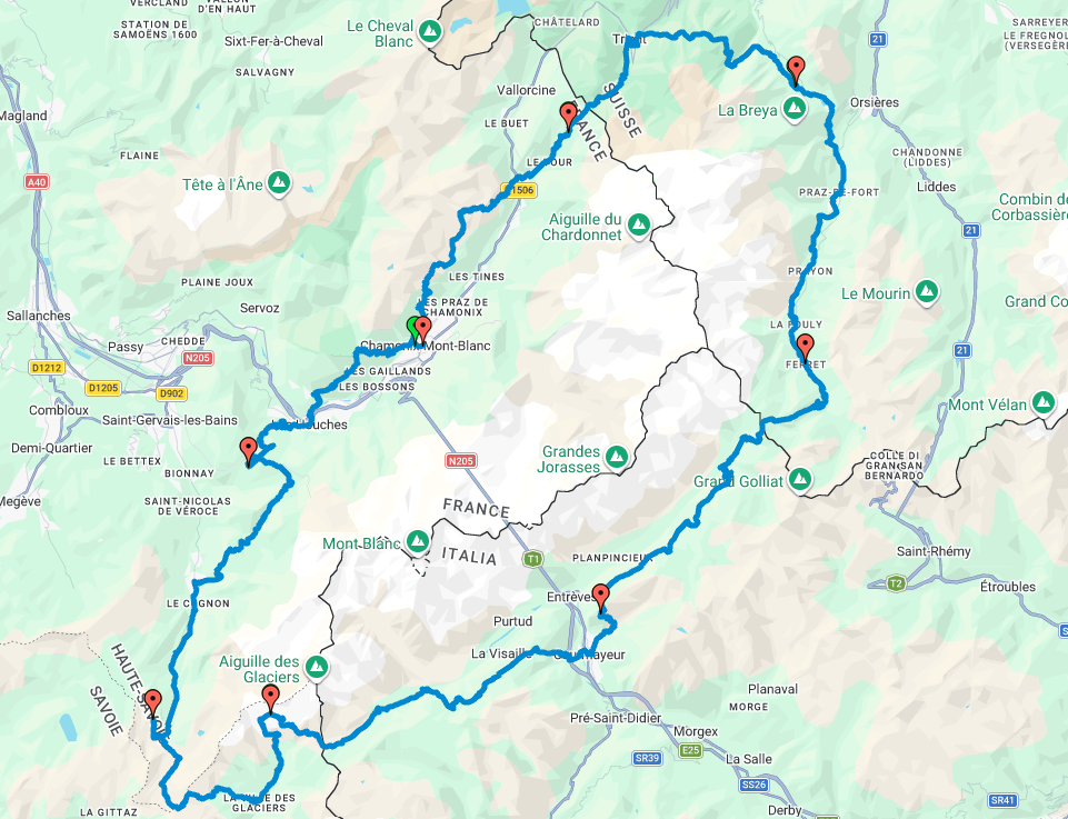
This map shows our actual route around the Tour du Mont Blanc, clockwise from Chamonix. You can zoom in on each stage and click on the track to see the stage name, the date, the distance and the ascent. It’s our exact route, not a smoothed-out or “official” version, and you can tell on the map: several sections leave the classic TMB trail to follow variants.
Our variants compared with the classic route (and why)
If you compare our route with a “standard” itinerary found elsewhere, you’ll notice differences. There are two reasons for that: we walked clockwise, which mechanically reverses the logic of the stages compared with the classic anticlockwise direction, and we deliberately took certain variants rather than the main route. That’s also why our total (180.5 km or 112 miles, +11,995 m) exceeds the “official” figures usually quoted (170 km or 105 miles, 10,000 m): each variant adds a little distance and ascent compared with the reference route.
The most significant one, and the most visible on the map, is the Day 5 detour to the Refuge Robert Blanc. This refuge isn’t on the main TMB trail, it’s a variant in its own right, and the approach is tough: it’s the day we climbed the most of the whole tour, 29.5 km (18 miles) and 2,500 m of ascent in a single stage, to reach a refuge perched at 2,750 m, without showers, in a completely mineral setting above the Vallée des Glaciers. On the map you can clearly see this section veer away from the “classic” route that carries straight on towards the Croix du Bonhomme. We didn’t take it by chance or by mistake: it was a deliberate choice, and looking back, one of our best memories of the tour (I explain why in more detail in the article on Tour du Mont Blanc refuges). But if you want to reproduce our itinerary exactly, be aware that it’s clearly not the easiest or the shortest variant: you need to be in good shape and ready to commit a little more than on the main route.
Two lessons if you’re preparing your own route from ours: first, don’t treat our map as a simple copy of the official trail, and check at each stage whether you’re on the main route or on a variant before you set off. Second, if a variant such as Robert Blanc appeals to you, check the ascent for that day in the table further down, as some of them lengthen the stage considerably compared with the classic itinerary.
The GPX track to download
If you want to use our itinerary as a base for preparing your own, here is the complete GPX file for the 8 days, ready to import.
This file contains the 8 stages separately, each named with the start, the finish, the date and the distance. I built it from our real GPS tracks recorded day by day during the trek, then cleaned and lightened it so that it stays easy to import (you don’t need thousands of points per stage to get a track that’s faithful to the metre).
To use it out in the field, you can import it into the Cartes IGN app, into Komoot, or into any app that accepts GPX files. I go through the apps and the complete method for finding your way without a guide in my article on how to hike the Tour du Mont Blanc without a guide.
One important point: this is our own track, clockwise, with our own choice of variants. If you set off anticlockwise on the classic route (the best documented, the one most guidebooks follow), use it as a reference for terrain and ascent rather than an itinerary to follow to the letter.
The Tour du Mont Blanc stages on the map, day by day
To see at a glance what each stage represents on the map:
| Day | From → To | Distance | Ascent / descent |
|---|---|---|---|
| Day 1 | Chamonix → Les Écuries de Charamillon | 20 km | +2,000 m / -1,160 m |
| Day 2 | Charamillon → Bon Abri (Champex-Lac) | 21 km | +1,250 m / -1,620 m |
| Day 3 | Champex → La Fouly | 20 km | +870 m / -600 m |
| Day 4 | La Fouly → Refuge Bertone | 25 km | +1,570 m / -1,280 m |
| Day 5 | Bertone → Refuge Robert Blanc | 29.5 km | +2,500 m / -1,700 m |
| Day 6 | Robert Blanc → Refuge des Prés | 20 km | +1,095 m / -1,900 m |
| Day 7 | Les Prés → Refuge du Fioux | 24 km | +1,350 m / -1,760 m |
| Day 8 | Fioux → Chamonix (back to the start) | 21 km | +1,360 m / -1,870 m |
| Total | 180.5 km (112 miles) | +11,995 m / -11,890 m |
If you’re still wondering which duration suits you, I compare the 3, 4, 5, 7, 8 and 10 day formats in detail, each with its own stage table, in my article on how many days to plan for the Tour du Mont Blanc.
Map of the Tour du Mont Blanc refuges
A TMB map without the refuges isn’t much use: they determine where you can actually stop. Here is where the main places to stay are, area by area.
| Area | Country | Main accommodation |
|---|---|---|
| Les Houches / Bionnassay | France | Refuge du Fioux, Auberge du Truc, Refuge de Miage |
| Les Contamines | France | Refuge de Nant Borrant, Refuge de la Balme, Refuge des Prés |
| Col du Bonhomme / Les Chapieux | France | Croix du Bonhomme, Refuge des Mottets, Refuge Robert Blanc (variant) |
| Val Veny / Courmayeur | Italy | Rifugio Elisabetta, Rifugio Maison Vieille, Rifugio Bertone |
| Italian Val Ferret | Italy | Rifugio Walter Bonatti, Rifugio Elena |
| Swiss Val Ferret | Switzerland | Gîte de La Fouly, Auberge des Glaciers |
| Champex / Trient | Switzerland | Auberge Gîte Bon Abri, Relais d’Arpette |
| Chamonix valley | France | Écuries de Charamillon, Refuge du Lac Blanc, Refuge Bellachat |
On the My Maps map above, every refuge where we actually slept is marked with its details. For prices, opening times, how to book and our honest opinion refuge by refuge, it’s all in my article on the Tour du Mont Blanc refuges.
Which map should you use on the trail: paper or digital?
As a complement to our GPX track, there are two paper references if you’d rather not depend solely on your phone: the official FFRandonnée topoguide (GR TMB, ref. 028, with extracts of IGN maps included) and the IGN 1:25,000 maps that cover the massif. We had the topoguide in our bag alongside our GPS tracks, a real safety net in case of a flat battery.
I go through the whole navigation method, apps included, in the article on the Tour du Mont Blanc without a guide. This map is designed for the big picture and for preparation beforehand, not to replace a real-time navigation tool on the trail.
In short
Where can you find a Tour du Mont Blanc map? You have our interactive map further up this page, based on our real 8-day GPS track. For a paper map, the FFRandonnée topoguide (ref. 028) and the IGN 1:25,000 maps of the area are the classic references.
Is the GPX track reliable for preparing my own itinerary? Yes, it’s our real track recorded day by day, simply lightened so that it stays easy to import. It matches our 8-day clockwise route with our own variants, to be used as a reference rather than a fixed itinerary if you set off in the other direction.
Do you need a paper map as well as GPS to hike the Tour du Mont Blanc? It isn’t compulsory but it’s a real safety net: paper never runs out of battery. We had both, the topoguide for context and our GPX tracks for real-time navigation.
If this map helps you prepare your own Tour du Mont Blanc, I’d love to know which direction and which duration you choose. Come and tell me in the comments or on Instagram.